 GeoData.NZ
CURRENT METERS
Type of resources
Topics
Keywords
Contact for the resource
Provided by
Years
status
-
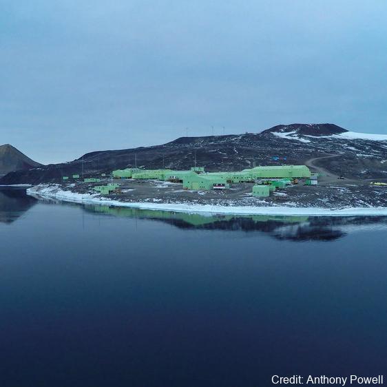
As part of the Scott Base Redevelopment Marine Monitoring Programme, the impact of Scott Base's activities on the local marine environment was assessed. Sampling took place at three sites around Hut Point Peninsula on the southern half of Ross Island during October – November 2019 to assess anthropogenic contamination. Two acoustic doppler current profilers (ADCP; Nortek Signature 500) were deployed, and set with a 2-minute sampling period in 1m vertical depth bins from the seabed to the underside of the ice. Instrument heads were kept ~0.5 m beneath the under-surface. ADCP data were downloaded, extracted from their raw formats, and averaged into 10-minute intervals. A magnetic declination of 141.09° E was applied to the measured current direction to correct the readings to reflect true north and a pressure offset was applied to standardise depths relative to ambient air pressure at the seawater surface. Information on habitats and benthic epifauna assemblage composition were collected using high resolution video across 2 25m transects at ~22m depth. Multiple overlapping passes were made across the seabed transects at ~0.5 m depth contours between ~20 – 26 m in order to create a 2D orthomosaic image of each site. Analysis of the diver-collected video was done using individual frames. The video along each transect was divided into 10 equal time segments and still frames were taken at random from the first, third, fifth, seventh and ninth segments. Eight video frames were analysed per transect (i.e., n=8 per transect and n=16 per site) by one individual to minimise observer bias. Sediment samples were collected by divers to determine contaminant concentrations and sediment characteristics (sediment particle size composition, organic matter content, organic carbon content and algal pigment content) at each site. Sponge species (Sphaerotylus antarcticus and Laternula elliptica) were collected for tissue contaminant analysis. Full description of methods is available at: https://doi.org/10.1007/s00300-023-03181-1 GET DATA: drew.lohrer@niwa.co.nz
-

In collaboration between Korea Polar Research Institute LDEO and NIWA, an oceanographic mooring was deployed close to the bottom depth in the Drygalski Basin (lat:-75.010487, lon:165.555680) on 6 March 2018 as a part of the ANA08C research cruise, and it was recovered on 5 January 2019. To monitor physical properties (Temperature, Salinity, Current) of deep water in the Drygalski Basin. GET DATA: https://kpdc.kopri.re.kr/search/992862c1-84d0-46aa-97dd-e2dcfb12357e
-

In collaboration between the Korea Polar Research Institute and NIWA, an oceanographic mooring was deployed close to the bottom depth near the Drygalski Ice Tongue (lat:-75.275700, lon:164.067300) on March 2020, and it was recovered on March 2022 (ANA12D research cruise) To monitor physical properties (Temperature, Salinity, Current) of deep water near the Drygalski Ice Tongue. GET DATA: https://kpdc.kopri.re.kr/search/17597739-8a74-45c9-8816-8adbcd11209f
-

In collaboration between the Korea Polar Research Institute and NIWA, an oceanographic mooring was deployed close to the bottom depth near the Drygalski Ice Tongue (lat:-75.275700, lon:164.067300) on 9 March 2018 as a part of the ANA08C research cruise, and it was recovered on 3 January 2019 To monitor physical properties(Temperature, Salinity, Current) of deep water near the Drygalski Ice Tongue. To monitor physical properties (Temperature, Salinity, Current) of deep water near the Drygalski Ice Tongue. GET DATA: https://kpdc.kopri.re.kr/search/9826749c-376a-4751-8812-702cec76c4c0
-

In collaboration between Korea Polar Research Institute and NIWA, an oceanographic mooring was deployed to the south of the Drygalski Ice Tongue (lat:-75.488417, lon:163.174350) on 12 February 2017 as a part of the ANA07C research cruise, and it was recovered on 7 March 2018. To monitor physical properties (Temperature, Salinity, Current) of ocean water in the south of the Drygalski Ice Tongue. GET DATA: https://kpdc.kopri.re.kr/search/9245184f-b187-4c1e-ad6f-32ed1f9493c8
-
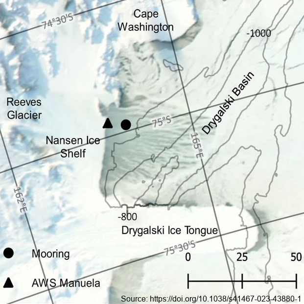
The mooring was deployed from February 2017 through February 2018 at 74.97° S, 163.96° E, approximately 7km east of the Nansen Ice Shelf in a region of TNB. The purpose of this study was to utilize data from a uniquely positioned and densely instrumented mooring to calculate HSSW production rates in TNB from continuous, in-situ observations. Moored instrumentation consisted of 7 SeaBird Electronics conductivity and temperature (SBE37-SM/SMP MicroCAT) sensors at depths of 47, 95, 119, 144, 168, 219, and 360 m and an upward-facing 600 kHz Nortek Acoustic Wave and Current (AWAC) profiler at 37 m depth, collecting both current velocity profiles in the upper ~35 m of the water column as well as Acoustic Surface Tracking (AST) measurements. Temperature and salinity measurements were validated against a shipboard conductivity-temperature-depth (CTD) cast performed upon deployment of the mooring. Temperature and salinity at 47 m and 95 m were additionally validated against a CTD cast performed upon recovery of the mooring. Full details of methods can be found in https://doi.org/10.1038/s41467-023-43880-1 GET DATA: ukm2103@columbia.edu
-

In collaboration between Korea Polar Research Institute and NIWA, an oceanographic mooring was deployed to the North of the Drygalski Ice Tongue (lat:-75.360083, lon:164.748633) on 12 December 2014 as a part of the ANA05A research cruise, and it was recovered on 10 December 2015. To monitor physical properties (Temperature, Salinity, Current) of ocean water in the north of the Drygalski Ice Tongue. GET DATA: https://kpdc.kopri.re.kr/search/1a10def2-13e7-4829-b46d-07bebb748ce2
-

In collaboration between Korea Polar Research Institute and NIWA, an oceanographic mooring was deployed close to the bottom depth near the Drygalski Ice Tongue (lat:-75.275700, lon:164.067300) on 9 March 2018 as a part of the ANA08C research cruise, and it was recovered on 3 January 2019. To monitor physical properties (Temperature, Salinity, Current) of deep water near the Drygalski Ice Tongue. GET DATA: https://kpdc.kopri.re.kr/search/9826749c-376a-4751-8812-702cec76c4c0
-

In collaboration between the Korea Polar Research Institute and NIWA, an oceanographic mooring was deployed close to the bottom depth near the Drygalski Ice Tongue (lat:-75.275700, lon:164.067300) on 5 February 2017 as a part of the ANA07C research cruise, and it was recovered on 5 March 2018. To monitor physical properties (Temperature, Salinity, Current) of deep water near the Drygalski Ice Tongue. GET DATA: https://kpdc.kopri.re.kr/search/023da26f-ba92-43ee-ab54-8ec5fbcf133b
-

In collaboration between Korea Polar Research Institute and NIWA, an oceanographic mooring was deployed to the North of the Drygalski Ice Tongue (-75.360083, lon:164.748633) on 3 March 2018 as a part of the ANA08C research cruise, and it was recovered on 4 January 2019. To monitor physical properties (Temperature, Salinity, Current) of ocean water in the north of the Drygalski Ice Tongue. GET DATA: https://kpdc.kopri.re.kr/search/90416713-7e1f-4c4d-a0b6-46c8deeea43e